

Woodend History

Aborigines on Merri Creek by Charles Troedel
Wurunjeri and other tribal clans
Aboriginal people have lived in the Macedon Region for at least 26,000 years, and the Wurunjuri, Dja Dja Wurrung and Taungurung tribal clans roamed along the grassy waterways of this region to hunt, fish and gather food across territory defined by tribal language, and bounded by geographical features such as mountain ridges, creeks or rivers.
The Wurundjeri people lived on the lands in and around the Yarra River and Maribyrnong watershed, which extended northwards to include the Macedon Ranges and the current towns of Gisborne, Hesket, Lancefield, Macedon, Riddells Creek and Romsey.
Dja Dja Wurrung tribes covered a very large area of central Victoria, including land around the present towns of Kyneton, Woodend and Malmsbury and the west side of the Campaspe River around Carlsruhe and Kyneton.
Taungurung tribes lived on lands that include the townships of Kyneton and Carlsruhe on the east side of the Campaspe River, and range through to Rushworth and Euroa in the north, extending east to Mt Buller.
At the base of Mount Macedon is an axe-grinding site important for the Gunung Willam-Balluk clan, part of the Wurundjeri tribe. The stone from Mt. William was shaped and sharpened on the rock. Some of the finished axe heads were traded during night-time ceremonies held around Hanging Rock.
Source: maggolee.org.au
Early Settlers
Woodend was first surveyed in 1836 by Major Thomas Mitchell on his third expedition. On 30 September, Mitchell climbed and named Mount Macedon, from the summit of which he had a view of Port Phillip. This opened the area to white settlement. (The mountain was first sighted by Hamilton Hume and William Hovell on their 1824 expedition to Port Phillip from NSW. They named it Mount Wentworth.)
When gold was discovered in the area (towards Bendigo and Ballarat) in 1851, gold fever hit Victoria. At the time, Melbourne’s population was 23,000. In just four months in 1852, 619 ships arrived carrying over 55,000 passengers. In the following decade the population grew to over half a million people - many of whom made their way to the goldfields to try their luck.
Woodend become a main thoroughfare to the goldfields and accommodated many gold diggers and their families. Travellers had to make their way through the dangers of the Black Forest (more below) to reach the safety of Woodend.
Woodend Post Office opened on the 20th July 1854. The oldest church in Woodend is the Anglican Church of St Mary’s, a Gothic bluestone building constructed in 1864. The church’s stained glass windows were produced by William Montgomery (1850 - 1927), former president of the Victorian Artists Society.
Nearby Mount Macedon township was largely established by Melbourne's wealthy elite in the post-gold rush era of the mid to late 19th century who used it as a summer retreat.
Source: wikipedia.org
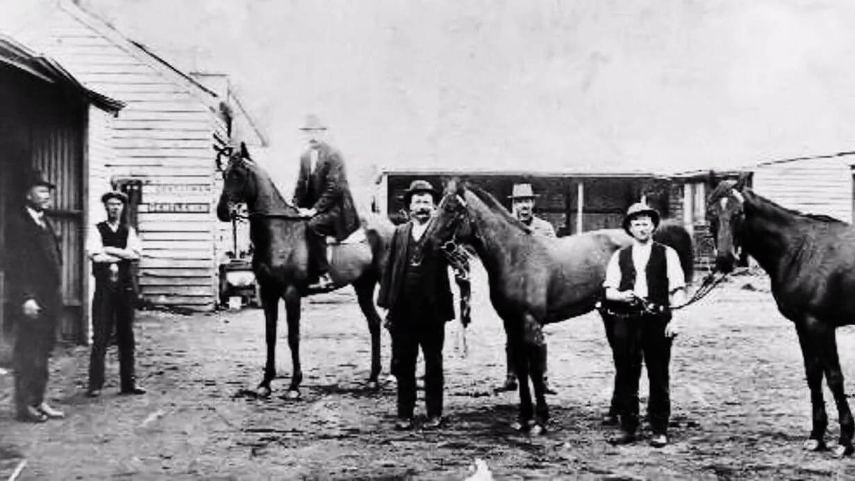
Men and horses outside the stables at the rear of the Commercial Hotel, which became Keatings Hotel and then Holgate Brewhouse. Image courtesty of Woodend & District Heritage Society

An 1855 cartoon of a bushranger robbing a traveller. Courtesy State Library of Victoria
The Treacherous Black Forest
In the 1850s, travellers to the goldfields had every reason to fear the journey through the dreaded Black Forest. The road from Melbourne to the Mt Alexander and Bendigo diggings took unsuspecting travellers through the forest, notorious for its terrible roads and the threat of assault and robbery by bushrangers (such as Captain Melville).
Ellen Clacy gave this description in her 1853 book:
“Towards evening, a party of four, returning from the diggings, encamped at a little distance from us. Some of our loiterers made their acquaintance. They had passed the previous night in the Black Forest, having wandered out of their way. To add to their misfortunes, they have been attacked by three well-armed bushrangers, whom they had been compelled to desist from their attempt, not, however, before two of the poor men had been wounded, one rather severely. Hardly recovered from this shock, than they were horrified by the sudden discovery in a sequestered spot of some human bones, strewn upon the ground beside a broken-down cart. Whether accident or design had brought these unfortunates to an untimely end, none know; but this ominous appearance seemed to have terrified them even more than the bushrangers themselves. These accounts sobered our party not a little, and it was deemed advisable to double the watch that night.”
Read the full tale of Ellen’s journey through the Black Forest.
Source: goldfieldsguide.com
Hanging Rock
Just 8kms from Woodend stands one of Australia’s most iconic landmarks, Hanging Rock.
Attempts to uncover Hanging Rock's Aboriginal name have proven difficult. Some think it is "Anneyelong" because of an inscription underneath an engraving of the rock made by German naturalist, William Blandowski, during an expedition in 1855–56. Historian and toponymist Ian D. Clark believes Blandowski misheard the name, and the word was possibly "Ngannelong" or something similar. The name "Diogenes Mount" was bestowed on the rock by the surveyor Robert Hoddle in 1843 in keeping with the spirit of several ancient Macedonian names given by Major Thomas Mitchell during his expedition through Victoria in 1836, which passed close to Hanging Rock. Others include Mount Macedon, Mount Alexander and the Campaspe River. Six other European names (Mount Diogenes, Diogenes' Head, Diogenes Monument, Dryden's Rock, Dryden's Monument and Hanging Rock) have also been recorded for the site.
To the early settlers, Hanging Rock became a place of recreation and tourism, as made famous by the 1900 novel by Joan Lindsay, Picnic at Hanging Rock.
Horse races have been held at Hanging Rock for over one hundred years and are still held twice a year, on New Year’s Day and Australia Day.
Source: wikipedia.org
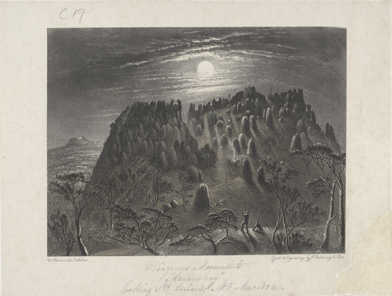
William Blandowski, Diogenes Monument "Anneyelong" looking Sth towards Mt Macedon, 1855/56.

Lavandula Swiss/Italian Farm
Swiss-Italian Heritage & Winemaking
The Daylesford & Macedon Region's distinct European atmosphere comes courtesy of post-war Swiss Italian migrants and the accompanying cool climate. See clusters of traditional stone farm buildings around Yandoit, Guildford and Franklinford, and striking buildings stand in Clunes and Creswick. Pay special attention to the stunning Lavandula lavender farm's Swiss-Italian farm at Shepherds Flat, and tour the Old Macaroni Factory in Hepburn Springs to discover magnificent frescoes.
Vineyards were originally established in the area more than 150 years ago (some as early as the 1840s), but it is only in the last 60 years that winemakers have begun to revive the local viticulture. Pioneering this renaissance were Tom Lazar (Virgin Hills) and Gordon Knight (Granite Hills) who started replanting vines in the 1960s and ’70s, with Granite Hills, like many wineries in the region, still a family-run operation.
Now the hills are crawling with boutique outfits producing small volumes of deliciously premium wine that has, seemingly by stealth, established the Macedon Ranges as one of the state’s most exciting regions for cool-climate pinot noir, shiraz, riesling and chardonnay, as well as rare and interesting drops from varieties such as lagrein, gewurtztraminer and tempranillo.
Source: Visit Victoria / RACV
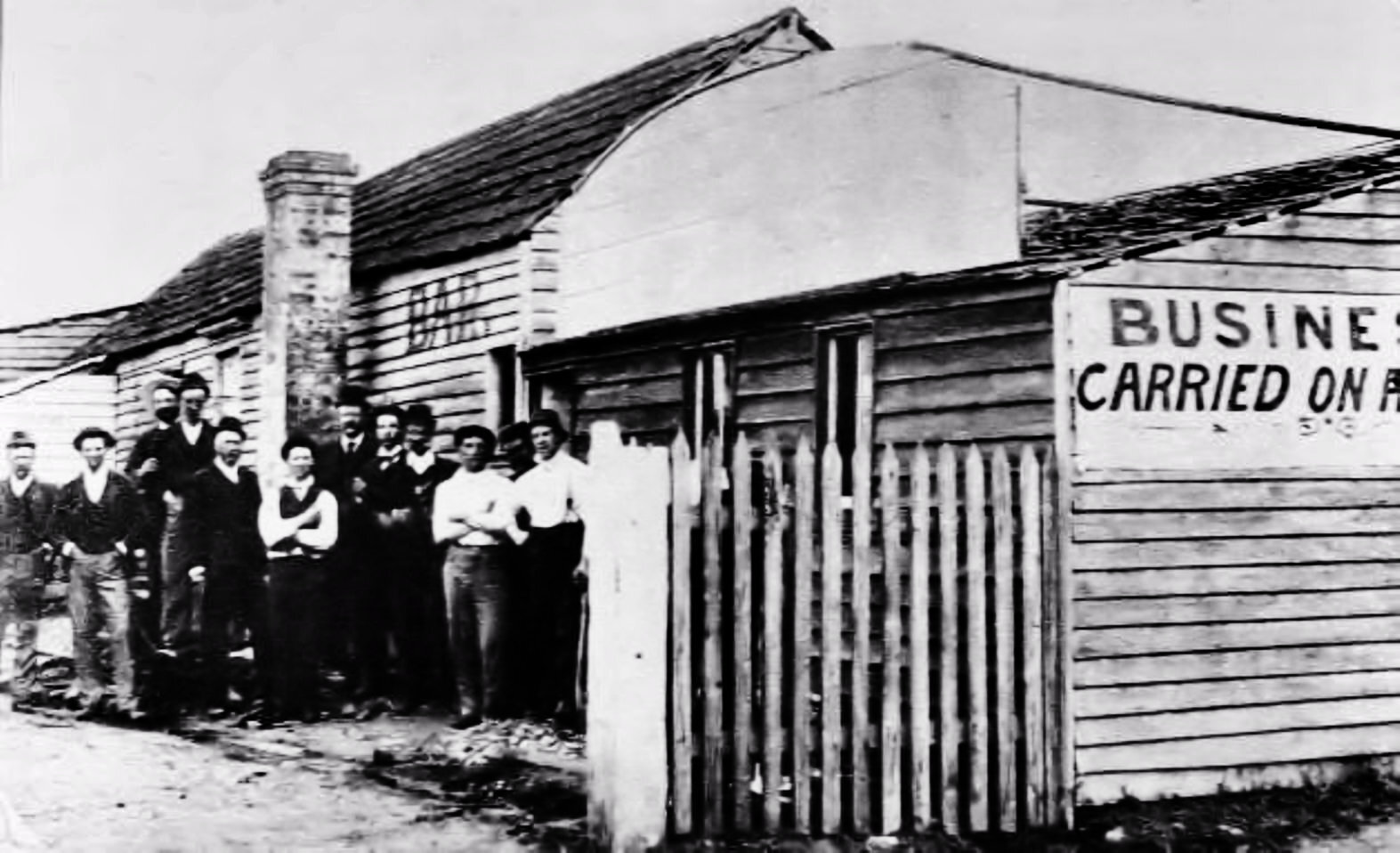
This was the first hotel to stand on the site of what we now know as Keatings Hotel. On November 1896, most of this building was destroyed by fire. This photograph by an unknown photographer records the fact that the bar was kept open. Where exactly this section of the building was is unknown.

Our records tell us that John and Fanny Keating were operating a butcher’s shop in Woodend in 1860, possibly even earlier. In 1897 Fanny Keating became the licensee of the Commercial Hotel - soon to become known simply as Keating’s Hotel - and in 1904 she and her husband purchased its freehold. The photograph from which this is copied looked like an 1860's image but the photographer, whose name appeared on the reverse side, is known to have only been in business between 1882 and 1883. It is of course possible that he was simply asked to make a copy from an earlier image.

Six men and three horses outside the stables at the rear of the Commercial Hotel (later Keatings Hotel and then Holgate)

High Street, Woodend, about January 1880. Landmarks which stand out on East Side are John Gilchrist's Store, George Hewett's Blacksmith Shop, Henry Sutton's two-storied Duke of Edinburgh Hotel, and the Railway Bridge. On the West side are the Victoria Hotel, Fitzsimons Commercial Hotel, and Islay House. Patrick Casey’s house is in the foreground. Casey built the footbridge in the foreground, over the rocky gutter and cut the opening in the fence in August 1875. Joseph Harris planted the two rows of trees and built the six-foot-high tree guards in July 1877.
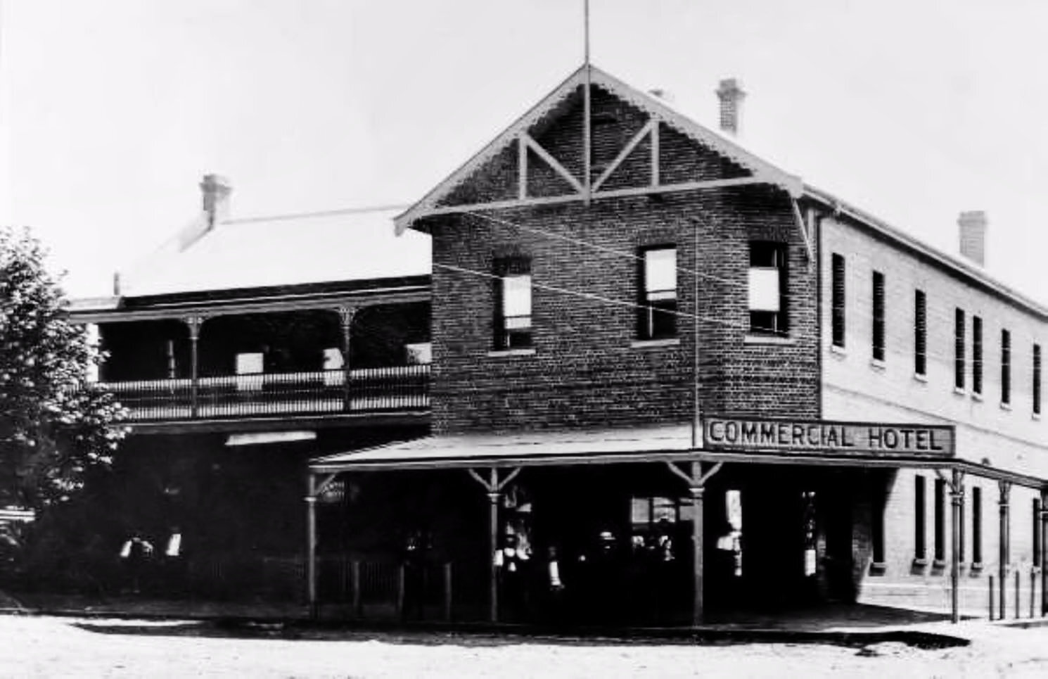
After the original wooden hotel building was destroyed by fire on the 11 November 1896, the Commercial Hotel was rebuilt as the substantial brick building, we know today. When Mrs Fanny Keating became the proprietor in 1895 it began to be called simply "Keating's Hotel." It remained in the Keating family until 1946 when it was sold to T.S. Foster. In spite of many different owners since then, the name "Keating’s" has remained - although it is now commonly known as Holgate Brewhouse.

West side, northern end of High St. Woodend. Showing buildings and shops including Bank, Commercial Hotel-1871-1902 (where Keating’s now stands on corner of Anslow St.), O'Brien Baker, Mechanics Institute.

High Street Woodend in 1918. Looking up High street towards Keating's (now Holgate) Hotel. Note the gravel road and lack of traffic. From a very early photo of unknown origin.

Keating’s Hotel Woodend. Date: c1920-1954. A photo from The Rose Series P.4171.

High Street, Woodend. Taken from window of Keating's Hotel on Empire Day, 1928

Snow Scene, High Street, Woodend. From a J.J. Keating (Postcard) series. Looking south towards clocktower. John Joseph Keating purchased the Woodend News agency from Mr. Rowell in 1914 and continued to operate it until the mid-1940's. He died in 1947. Note the verandahs on Keating’s Hotel, the clocktower and the wooden railings still around street plantations. These suggest that the photo was probably taken around the 1930's. Note also the Havelock tobacco sign on the building on left, and well rugged up man in overcoat & hat crossing street.
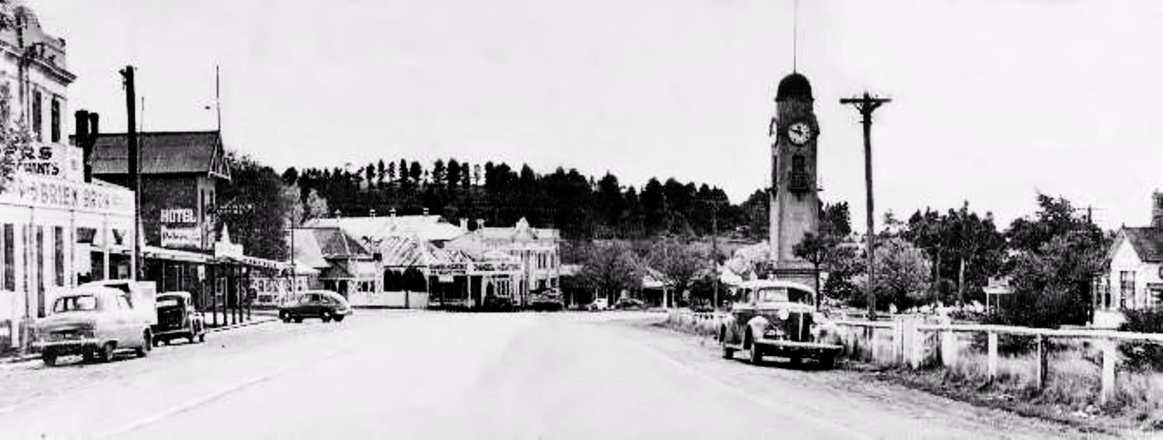
High Street Woodend, looking north. May 1952. View shows on left hand side O'Brien Bros, Keatings Hotel with verandah, Devon Lodge, Daniel & Keating, Mechanics Institute with rear building. Golf Course in background. Clock Tower and fenced plantation strip on right hand side.

Keating’s Hotel Woodend. Note verandah with awnings.

Chinka Steel making a speech outside Shire Offices, Mountain View Cafe & Keating’s hotel in background. Believed to be "Back to Woodend" celebrations, 1985. Betty Barned & John Shaw (far R. ) among onlookers.

High Street Woodend C1986. Note the Westpac Bank has yet to be 'modernised'. Also, Keatings Hotel still wears its paint. This was sand-blasted off in 1988 as part of extensive renovations carried out by the owners, Mr & Mrs Le Brocq.

Photo of Keating’s Hotel when painted white. 1986.
Special thanks to Tony Stidwell and the Woodend & District Heritage Society